Site Navigation

Illustrations

Figure 4. 1671-1672 map by Fr. Dablon, showing the Jesuit missions which had been established by that time at Sault Ste. Marie, Chequamegon Bay, Green Bay, Michilimackinac, and Manitoulin Island. This chart, which offers the earliest reference by a cartographer to the French presence at the Straits of Mackinac, bears the following caption: “Lake Superior and other places where are [located] the missions of the Fathers of the Company of Jesus included under the name of Outaouacs.” (Courtesy of National Archives of Canada, NMC-10296)

Figure 5. Map by the officer Lahontan, depicting the region from the estuary of the St. Lawrence as far west as the upper Mississippi River. This chart, from the 1703 English version of Lahontan’s account, portrayed the extent of geographical knowledge of New France in 1687-1689. Included on this map are “Villages of French, Hurons, Outaouas, Missilimakinac,” “Sauteurs [Ojibwas] and Jesuits house” at Sault Ste. Marie, “Village of French and 3 other Nations” at the foot of Green Bay, “Ft. St. Joseph” just south of Lake Huron at the head of the St. Clair River, “La Salle’s Fort” at the mouth of the St. Joseph River and his “Ft. Crevecoeur” on the Illinois River, “Ft. Kamanistigoyan” on the northern shore of Lake Superior, and “Ft. Frontenac” and “Ft. Niagara” near the eastern and western ends of Lake Ontario.

Figure 11. Map by Lahontan from 1687-1689, from the 1703 English edition. The two primary routes between the St. Lawrence settlements and the various interior posts were represented, passing via the Ottawa-Mattawa-French Rivers to Georgian Bay of Lake Huron, and via the upper St. Lawrence River and Lakes Ontario (Frontenac) and Erie. In addition, the officer also portrayed the passageway which extended between Lake Ontario and Georgian Bay, by way of the Toronto Portage route. His depiction of the water passage between Montreal and the New York-New England region, via the Richelieu River, Lake Champlain, and the Hudson River, emphasized the military and commercial traffic which passed along that route as well.

Figure 14. 1687-1689 map of the Straits of Mackinac by Lahontan, from the 1703 edition of his account. On the St. Ignace Peninsula, flanking the shores of East Moran Bay from south to north, were the French village, the enclosed St. Ignace mission complex, and the stockaded villages of the Hurons/Tionontates and the Ottawas. The extensive native fields stretched well to the north of these settlements. The other primary food source for both local residents and travelers, offshore fishing, was represented by 21 canoes working the waters off of Mackinac Island, with each craft containing three sitting paddlers.


Figure 19. Cargo manifest from 1694, listing government materiel for troops and native allies which was shipped to Ft. de Buade. Many of the civilian traders in the convoy, to whom these parcels had been entrusted for transport to the fort, halted en route and spent the winter and spring on the Ottawa River. During this time, they utilized and sold off much of the government-owned equipment and supplies from the shipment. (Courtesy of Archives Nationales du Québec)

Figure 24. Winter hunting scene from 1687-1689, plus a detailed portrait of snowshoes, as they were observed by the officer Lahontan. The artist depicted both moose (orignal) and elk (cerf) being pursued by native archers during the season when deep snow hampered the movement of the prey, while the hunters advanced easily atop the snowpack with the aid of snowshoes.


Figure 27. Two pages from the ledger of the prominent Montreal outfitter Monière, showing the accounts of the trading partners Raymond Baby and François Larche. The first half-page list is a roster of the peltries which were received in Montreal on August 26, 1715 from the two traders at the Straits, while the following longer list is a manifest of the replacement merchandise and supplies which were shipped to them at the fort on September 10, 1715. These records represent only a small fraction of the extensive commerce which was conducted at Ft. Michilimackinac during its first full year of operation. (Courtesy of Château Ramezay Museum Collection, Montréal)


Figure 28. First and last pages of the official expense account for the 1715-1716 campaign by the French and their native allies against the Fox nation and the concurrent establishment of Ft. Michilimackinac. Large amounts of the government-provided merchandise, supplies, and equipment were given to the native allies, in order to equip the participating warriors and to purchase provisions for all of the French and native forces. (Courtesy of Archives Nationales de France, Centre des Archives d’Outre-Mer, Aix-en-Provence, France)

Figure 29. Map from ca. 1717 of the Straits of Mackinac area. This chart, actually an updated version of Lahontan’s map of the area from 1687-1689, included both the new Ft. Michilimackinac with its adjacent village on the south side of the Straits, and the old Ft. de Buade with its French and native settlements and mission complex on the north side, at St. Ignace. (Courtesy of Newberry Library, Chicago, Edward E. Ayer Collection)

Figure 30. Artist’s reconstruction, based upon archaeological evidence, of the initial version of Ft. Michilimackinac and a small portion of the adjacent Ottawa village, on the southern shore of the Straits, ca. 1720. At this time, the church and attached priest’s residence were located outside of and against the western wall of the fort stockade. There, the priest could serve the native and French residents of the community, as well as the seasonal and short-term visiting populations. (Courtesy of Mackinac State Historic Parks)

Figure 33. Hiring contract from 1735 of the voyageur Simon Réaume. In contrast to the men who were employed to winter over in the Straits region, many others, such as Réaume, were hired to make a round trip between Lachine and Mackinac during the summer and fall months, after which they wintered at their homes in the St. Lawrence Valley. (Courtesy of Archives Nationales du Québec)

Figure 36. Plan of Ft. Michilimackinac, drawn by Lotbinière in 1749. The open waters of the Straits, not shown on his map, lay just to the north of the post, toward the bottom of the page. The old stockade walls from the 1730s had been left in place when the new walls and corner bastions were erected during the 1744-1748 period, some six or seven feet beyond the old walls. The older, inner enclosure was portrayed on the drawing by broken lines, as were also the low picket fences which surrounded the property of each building. Two long rows of houses filled the southern half of the fort, while one short row was located along the east wall and another long row flanked the north wall. The church, priests’ residence, and blacksmith’s shop occupied the western side of the fort, while the subterranean powder magazine was isolated in the southeastern corner area. An icehouse, baking oven, and meridian post were located in the triangular enclosure which extended toward the west from the main stockade, and two additional baking ovens and a stable were positioned in the open area to the south of the fort. (Courtesy of National Archives of Canada, NMC-12806)


Figure 37. 1745 hiring contract of the voyageur Simon Réaume, by the prominent traders Marin de La Perrière and Dequindre, who were active for many years at both Ft. Michilimackinac and Ft. St. Joseph. Of particular interest is the document itself, which was written out in advance by the notary Adhémar, for later generic usage. During the writing process, the notary left various areas of the sheet blank, in which he later inserted the specific details of the engagement: the names of the voyageur and the hirers, the destination of the voyage, the amount and type of remuneration, the names of the attending witnesses, and the date and place of recording of the contract. This clerical technique predated by several decades the later use of pre-printed forms. (Courtesy of Archives Nationales du Québec)

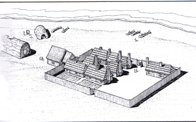
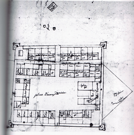
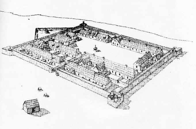
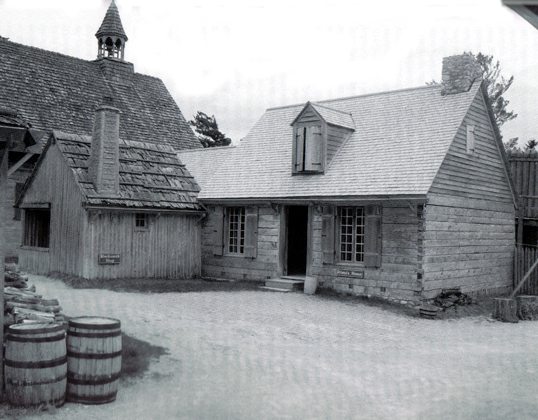
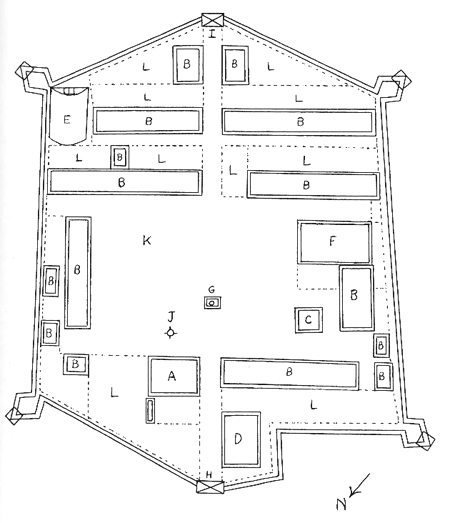
Figure 39. Lotbinière’s 1749 map of Ft. Michilimackinac, redrawn here to translate and clarify the officer’s labels. Broken lines indicate the old stockade walls, which had been left standing when the new outer enclosure walls and corner bastions were built; they also indicate the low picket fences surrounding the individual properties. Each structure is labeled with its owner or occupant, and in some cases with a letter B to indicate “Boards,” indicating that the roof of the structure was covered with split or sawn boards rather than with bark panels.
1. powder magazine, 2. Monsieur Chevalier, 3. Joliet, 4. Lefevre, 5. Charles Amelin, 6. Desrivière, 7. Dufresne, 8. Bertrand, 9. Cecile, 10. Michel Amelin, 11. Chevalier, 12. Jasmin, 13. Jiason (Giasson), 14. the Amelins, 15. Monsieur Langlade, 16. Chesnier, 17. Monsieur the Commandant, 18. Bourassa, 19. Monsieur Gonneville, 20. Beaulong, 21. Parent, 22. Monsieur Douaire, 23. L’Eguille (Daghuilhe), 24. Monsieur Lefevre, 26. Chaboyé (Chaboillez), 27. Hubert, 28. the Sergeant, 29. Amiot, 30. Ains (Ainsse/Hains), 31. Richot, 32. Blondeau, 33. Nanette Blondeau, 34. Monsieur Coulonge, 35. guardhouse, 36. house of the junior officers, 37. St. Germain (Adhémar crossed out), 38. Monsieur Chevalier, 39. Monsieur Chevalier, 40. Piquet, 41. blacksmith’s shop, 42. house of the Jesuits, 43. church, 44. yard of the Jesuits, 45. garden, 46. crucifix, 47. parade ground, 48. meridian post, 49. baking oven, 50. icehouse, 51. baking ovens, 52. stable of Monsieur Langlade.

Figure 40. Artist’s reconstruction of Ft. Michilimackinac in 1749, based upon Lotbinière’s drawing and observations from that year. However, the church and priests’ residence have been protrayed here with walls made of upright posts, rather than of horizontal timbers. In addtion, many of those individual roofs which were indicated by the officer as being covered with split or sawn boards have been depicted here as being covered with panels of bark. Finally, the roof of the earth-covered powder magazine has been presented here as gabled, rather than of low, flat construction. (Courtesy of Mackinac State Historic Parks)


Figure 41. First and last pages of the 1752 inventory of the trading store of Claude Marin, Sieur de La Perrière, at Ft. Michilimackinac.This prominent trader operated for many years at both the Straits and Ft. St. Joseph. The inventory document was signed by the missionary du Jaunay, the commandant Beaujeu, and the resident traders Baribeau, Langlade, and Bourassa. (Courtesy of Chicago Historical Society, France in America Collections)

Figure 42. Reconstructed southwest rowhouse at Ft. Michilimackinac. Built with walls of upright posts set into the ground and chinked with clay, the triple house is roofed with panels of bark. These panels are held in place with horizontal saplings which are nailed through the bark into the rafters. The lower portion of the chimney is constructed of stones and mortar, while the section above the main wall is made of wattle and daub, a framework of posts and interwoven saplings plastered with clay.

Figure 43. Priests’ house on the right and the blacksmith’s shop, with they owned, on the left (with the church off to the distant left), at the reconstructed Ft. Michilimackinac. The forge building was constructed in poteaux en terre style, with vertical posts set into the earth, while the home of the clerics was built by the more durable and insulated pièce sur pièce method, with squared timbers set one atop the other.

Figure 53. Crown Collection map showing Ft. Michilimackinac in ca. 1768. A. the commandant’s house, B. houses belonging to the merchants and others, C. the guard house, D. the King’s provision store[house], E. the magazine, F. the church, G. the well, H. the water gate, I. the land gate, J. the flag staff, K. the parade, L. gardens. Redrawn after the original.

Figure 57. Artist’s reconstruction of Ft. Michilimackinac during the 1769-1770s period. It is based upon the Nordberg map of 1769, with the addition of the barracks building which was constructed in latter 1769. (Courtesy of Mackinac State Historic Parks)

Figure 65. View from the water gate across the fort to the land gate at the reconstructed Ft. Michilimackinac. During the years of the American Revolution, many expeditions for both commerce and warfare were sent off and welcomed back at this lakeside gate.

Figure 60. Reconstructed southwest rowhouse, church, soldiers’ barracks, and stockade of Ft. Michilimackinac, with the Mackinac Bridge spanning the Straits in the background. In the foreground is an open shelter which has been built over the excavated remains of the original stone fireplace at the western end of the south-southwest rowhouse.