Paddling Across the Peninsula
An Important Cross-Michigan Canoe Route During the French Regime
By
Timothy J. Kent
ISBN: 0-9657230-3-8
Use drop down menu to determine price after shipping according to your location
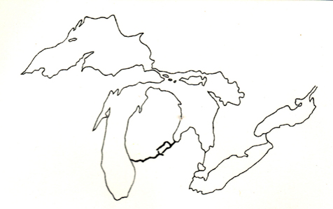
During the prehistoric era, native travelers discovered a series of interconnected rivers which formed a water highway across the entire Lower Peninsula of Michigan. When Frenchmen arrived in the Great Lakes region during the 1600s, they were guided along this crucial canoe route by their native hosts.
Through meticulous research, the author has assembled a full array of maps from the French era which depict the eastern and western halves of the route, as well as the overland portage which connected the two halves. In addition, he has located these water and land features on modern maps. Finally, his work has uncovered a number of original French documents which describe the usage of this cross-peninsula highway, by both native and French paddlers.
The book, containing 63 pages within soft covers, is copiously illustrated with five ancient maps dating from 1656 to 1744, as well as six modern maps. In addition, it contains a portfolio of twenty photographs, with detailed accompanying text, which show the author and his family authentically recreating the ancient native and French methods of traveling by birchbark canoe, including carrying the craft over land portages, repairing it, and using it as a shelter.
“Kent, an in-depth researcher and a respected author, is one of the few historians who delve into the French era of midwestern history. This book will be of great interest to historians and serious re-enactors of the French regime in the Great Lakes region, and also to paddlers and canoe enthusiasts everywhere.” -David Armour, Deputy Director and Historian, Mackinac State Historic Parks